The survey is not particularly easy to respond to, for example it asks people to provide information about all of the public sector data they use. That would be a lot of information for many organisations and people!
There is a page listing all of questions and a separate page with an online survey to answer the questions. It does not say that you can email answers to the team so I would recommend filling in the online survey.
If you focus on the key questions 12-14 it might only take about 5-10 minutes. You can save progress as you go, but you can’t change your answers once you have submitted the questions
I recommend that you respond politely and honestly throughout. Do use your own words and thoughts. In case it’s useful to help your thinking then here are some tips on what to expect and how I responded.
Questions 1-7 are about your organisation and job.
I both work with multiple organisations / sectors and use data as a citizen so found this section confusing as it assumes people only use data for a single organisation. Others may find it simpler.
Questions 8-11 are about public sector data you use in your work.
Again, it wasn’t obvious how to answer these. I use, experiment with, imagine, and campaign to improve lots of data. But this wasn’t why I was responding to the survey and it wasn’t clear what this information would be used for.
So I kept it simple and skipped questions 8 and 9, they’re optional questions, and answered don’t know/other to questions 10 and 11 as they are both mandatory questions.
In response to question 11 I gave a couple of suggestions of other issues that affect both businesses and individual citizens, specifically “inability to contact data holder” and “inability to request data corrections”.
Questions 12-14 are about existing public sector data sets that you or your organisation would like to access that you currently do not. This is where I chose to respond about address data
For Question 12 I responded “Administrative address and mapping data created and maintained by public sector organisations as part of their public task“.
Question 13 is about the access issues. I responded with “Cost”, “Data Quality” and “Legal Frameworks”. In the “Other” section I gave a short description of the legal risks and current business models, saying:
“1. The intellectual property status of many public datasets that contain this data is unclear. This is because of unclear licensing and derived database rights. Public sector organisations can interpret this situation differently, for example Ordnance Survey’s recent contact with 34 local authorities https://www.owenboswarva.com/blog/post-addr44.htm. This risks a chilling effect where people are unwilling to invest to innovate.
2. Some of the public sector organisations that create and maintain this data, for example the Ordnance Survey, are run as government companies. This creates an incentive to protect their rights and monetise the data, rather than to maximise the public good. They should instead be funded to publish this data for free.“
Question 14 is about the benefits. I responded:
“Address data, and geospatial data more broadly, are foundational datasets that are used extensively across the public and private sectors.
There are many current use cases that would be improved by making the current datasets freely available under an open licence; use cases that will be improved because effort and money that is currently spent buying datasets and understanding licences will be spent on other more useful activities, and new use cases that will be created by innovators – in the public, private and third sectors – who currently feel hindered by the cost and/or legal uncertainty.
The EU estimates it will receive up to €2 billion per year in economic growth from making this data available for free under an open licence. “
Questions 15-16 are about new datasets that the government could collect.
I chose not to respond on these topics in this survey.
Questions 17 – 19 is about public sector data that would help people develop or use AI.
My response to question 17 pointed out the existing set of complex copyright questions about data and AI and how open data would help:
“Publishing address data, and geospatial data more broadly, as open data for free would help me develop or use AI as it will reduce one element of the current complex set of copyright issues that surround AI products.“
Questions 20-21 are broad free-text questions
Questions 22-25 are about staying in touch for more research.
If you care about increasing access to UK address data, or geospatial data more broadly, then this is an opportunity to let the UK government know.
If you focus on the key questions – numbers 12-14 – about existing public sector data that is hard to access then it should only take 5-10 minutes.
If you’re not sure about why this is important then some reasons follow.
If you already know how you want to respond then simply skip directly to this post some tips on how to respond and see the responses I sent in.
Address data is incredibly valuable but too difficult to access
In the UK addresses – for example, “29 Acacia Road, Beanotown” – are maintained by local authorities. The list of address changes as flats, houses and offices get developed and demolished. These local lists are collected into a national dataset and made accessible to other public and private sector organisations.
While this happens address data gets tangled up in a complex web of other organisations who end up holding some intellectual property rights in the data, particularly the Royal Mail and the Ordnance Survey.
The Royal Mail is a business and the Ordnance Survey is a business owned by the government. Because they are businesses their primary goal has become to generate revenue for themselves by selling the data, rather than maximising the public good that could be created from using the data.
This reduces the value that can be created from address data.
In practical terms that reduced value results in worse services. For example more occasions when people struggle to get home insurance, register with a doctor, or apply for a benefit because their address is not recognised by the computers.
At a more societal level it means it’s just that bit harder for businesses to get started or public services to be built. People spend time and effort buying data licences and then paying lawyers to help interpret those licences, when that time could instead be spent building better services for us to use.
So, as well as the poorer services that some people experience, there are other services that simply do not exist because businesses and public service organisations could not build them.
Put together that means lost services, businesses, and jobs.
As a practical example, recently the Ordnance Survey, a company owned by the government, paid their lawyers to contact at least 34 local authorities to ask them to check if they had released a list of addresses in error. Whoever is in the right on the legality of each data release, it’s clearly more public money not being spent on providing public services.
Overall the issues add up to big financial numbers and the UK is increasingly becoming an outlier as other countries make this kind of foundational data openly available for free. The EU has estimated that by 2028, its own plans for the wider availability of geospatial data – including addresses and maps – will generate up to €2 billion per year in economic growth.
So poorer services and weaker growth. Sounds like the UK is missing out by not making its own geospatial data more accessible.
Unfortunately despite the public promises successive governments have failed to deliver change.
Recently the current UK Government even appeared to confirm that the civil service had made no assessment of the potential benefits. Which was surprising. It makes you wonder what people have been doing all of these years.
So will responding to this latest survey change anything?
Honestly, it’s impossible to tell. All most people can do is continue to request and provide evidence of the potential benefits.
If the government, or its civil servants who work on data policy, believe the benefits are not significant then at least this might encourage them to provide their own evidence for public debate or run some experiments that could help the UK learn how to make data more accessible.
After all, addresses and geospatial data are relatively easy to make more available. The potential issues are well understood. The real challenge is modernising government institutions, and that’s a challenge that the current government has said it is willing to take on.
So, let’s ask them to try.
Read on to find out how to respond to the survey and ask for better access to address data.
Unfortunately the paper’s analysis is incomplete and unlikely to have any real impact.
This risks harm to people and will contribute to a failure to deliver the promised £11bn/year of economic benefits.
The paper proposes an ABC of ethical use of location data
The paper recognises that it is “vital that its use retains public trust and confidence”. It used a public dialogue, quantitive survey, and analysis from the Geospatial Commission’s team to suggest three ethical building blocks, on top of existing legislation, to help achieve this goal of public trust.
The building blocks are:
Accountability – Governing location data responsibly, with the appropriate oversight and security
Bias – Considering and mitigating different types of bias, and highlighting the positive benefits of location data
Clarity – Being clear about how location data will be used and the rights of individuals
Unfortunately, the paper’s analysis is incomplete
The paper’s analysis is incomplete, to provide just four examples it:
has a smaller set of considerations than other geospatial ethics work
implicitly assumes that all people have the same capacity to make decisions
does not discuss ethical issues about places
and does not consider the business models of the organisations that collect and provide location data
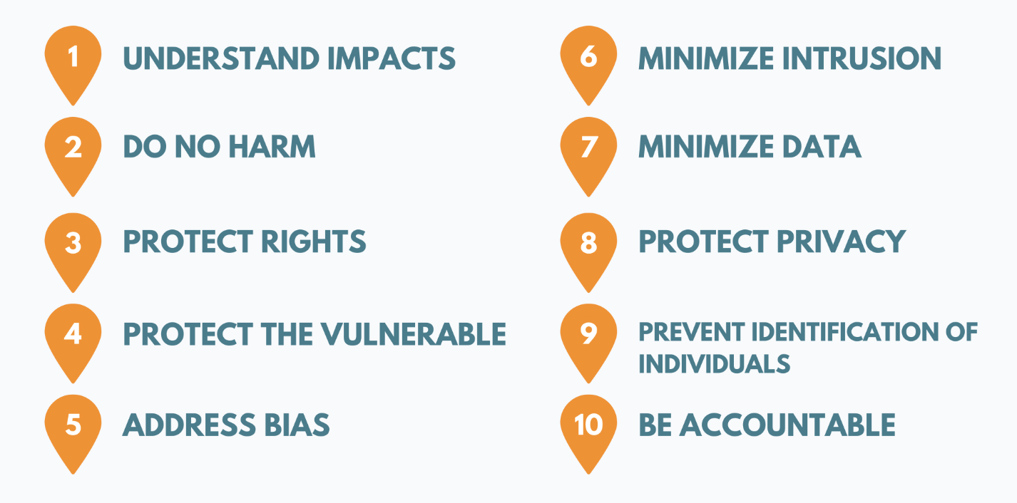
There are three ethical building blocks compared to ten principles in the Locus Charter
These building blocks are a subset of the principles captured in the international Locus Charter for responsible use of location data.
As a result the proposed building blocks do not include protecting the vulnerable, protecting rights or data minimisation.
The Locus Charter has 10 principles, the Geospatial Commission covers accountability (#10), bias (#5) and adds clarity.
Several UK organisations, from the public, private and third sectors, participated in the global work that created the Locus Charter.
The paper does not explain why this existing work has not been reused or why only a subset of the Locus Charter has been included.
Not all individuals or decisions are the same
The paper states that it wants to help individuals make “more informed, meaningful choices” but does not recognise that not all individuals or decisions are the same.
There is no consideration of factors such as someone having no choice in whether to use a service, having low skills, being busy or stressed when they make a decision, how people’s decisions can affect other people, or how some people may be more at risk than others.
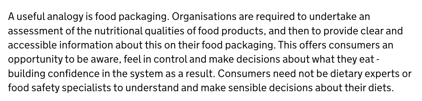
This analogy forms part of the Geospatial Commission’s guidance. It is not a useful analogy. Making food safe requires many more activities than clear packaging. For example there are controls on food ingredients, training requirements for staff, and inspections by regulators.
The paper does not even reference the age-appropriate design code – a statutory code of practice produced by the UK’s Information Commissioner’s Office.
This code was intended to help protect and empower children by ensuring that more services are designed for their needs. The design code states that online services likely to be accessed by children should have geolocation options turned off by default.
The ethics of place and communities are neglected
The paper says that location data is about people, events, and places. Unfortunately, the ethical considerations that are discussed are mostly concerned with location data about individual people, or personal location data, the ethics of place and communities are neglected.
You would look in vain if you wanted to find discussion of ethical issues such as:
whether and how places – such as domestic refuge centres, abortionclinics or military bases – might need to be protected to prevent harm
whether and what decisions about the collection, sharing and of location data should be made by devolved administrations, city-regions, or the local communities that live in those places
Business models are an ethical issue but are not mentioned
Finally, many ethical issues stem from business models and incentives.
Neither the business models of the UK’s public sector geospatial agencies or those of the private sector firms, for example those in the advertising industry, that collect and manage location data are considered.
The paper is unlikely to have any significant impact
These are just four gaps in the analysis. I could go on, for example there is no recognition of the distributional impacts of the benefits and risks across different places and different groups of people, but as well as the incomplete analysis the paper is unlikely to have any significant impact.
This is because of:
the hugely diverse range of organisations and people it needs to affect
it is not sufficiently grounded in how teams work
it does not assess existing legislation or consider legislative change
Will thousands of people in a huge range of sectors read the paper?
As the paper says location data is ubiquitous. To create impact the Geospatial Commission needs to affect the behaviour of the thousands of organisations and people that collect, share, use and maintain location data..
The paper uses examples from a huge range of sectors and disciplines: transport, wearable technology, drones, space, smart homes, healthcare, statistics, social sciences, online services, public services, private services, and the UK’s ubiquitous potholes.
A pothole in Newport on the Isle of Wight, CC-BY-3.0 by Editor5807
Are organisations and workers in all of these sectors and disciplines likely to follow the recommendations in the paper? Does the paper align with existing practices, challenges, and opportunities in their contexts? Are they even aware of the Geospatial Commission?
Insufficiently grounded in how teams work
Rather than looking at policy papers, the teams who build products and services or perform statistical analysis tend to use manuals/guides, reuse openly available code, data and design patterns, and learn from how other teams do their work.
Within the UK this is also one of the reasons why Government Digital Services worked in the open. They regularly blogged, published open source code, and created a service design manual for public services built by central government.
Consciously or not, these guides, source code and data embody particular types of ethical practices and decisions made by teams, but it is noticeable that the Geospatial Commission’s work is stuck at the level of principles and policy papers, rather than producing their own examples and guides or by embedding their proposed principles into the existing manual and guides.
It does not appear that the Geospatial Commission have thought about how to take their work to the places where digital and statistical teams do their work.
Organisations and people will also respond to legislation and regulation, but while the paper states that existing legislation provides a baseline it does not describe the existing legislation or assess whether the legal and regulatory framework needs to change.
As previously mentioned the paper does not cover the ICO’s Age Appropriate Design Code and its section on geolocation.
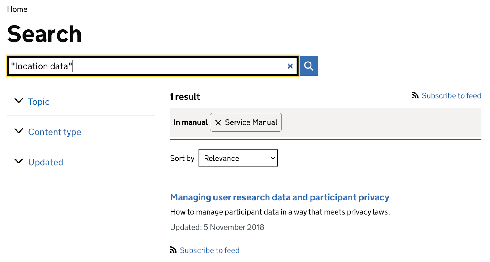
It also does not mention the existing legal definition of location data, under the PECR regulations, a definition which is narrower than the Geospatial Commission’s work, the accompanying guide, and the work that has taken place in multiple organisations to comply with PECR.
The PECR definition of location data is narrower than the Geospatial Commission’s definition
The Geospatial Commission was established as an “independent, expert committee” but despite this independence the paper does not reference the UK government’s ongoing plans to reform data protection law or assess whether the changes will help or hinder the Commission’s strategy.
Meanwhile new changes to legislation are not considered in the paper. No reason for this is given.
These changes might be to help deliver on the Geospatial Commission’s objectives of economic growth, to enforce the Geospatial Commission’s proposed “ABC” building blocks, or to help protect people and communities from the increased risks that more data collection, sharing and use will cause.
Even the simplest of legal changes, such as making personal location data a new type of special category data, or powers for appropriate public sector organisations or regulators to make more reference data about places openly available and reusable, are not considered.
This paper will not help deliver the promised benefits
I am deliberately not forming opinions on whether the Geospatial Commission’s goal of creating £11bn of economic value from increased use of location data is feasible and/or desirable, but I cannot see how this paper will help.
As the Geospatial Commission correctly identified, their strategy needs to retain public trust in the use of location data. A failure to do this risks harm to people and will contribute to a failure to deliver the promised benefits. And failing to deliver those promised benefits will harm the government’s wider economic objectives. This paper will not help retain public trust and can only contribute to the inevitable failure to deliver the benefits.
Rather than an incomplete set of ethical building blocks we need more practical guidance and tools for teams to use, and an assessment of the legislative and regulatory framework that the government’s proposed larger location data market will need.
About me
Hello. This is the personal website of Peter K Wells. I do politics, policy and delivery to try to make data and technology benefit everyone. I also do bad jokes and music references.
This website stores cookies on your computer. These cookies are used to provide a more personalized experience and to track your whereabouts around our website in compliance with the European General Data Protection Regulation. If you decide to to opt-out of any future tracking, a cookie will be setup in your browser to remember this choice for one year.